Coastal communities in Plaquemines Parish plot the future with LA SAFE
by Monica Barra
photos by Zack Smith
Poised over a table-top–sized map of lower Plaquemines Parish, Darilyn Turner led the June 2017 discussion at the community center in Davant, Louisiana. “Over the coming decades,” she began, “flood risk and land loss will increase across the coast, with the population moving upland, to higher-ground areas. Drainage and water management are one of the biggest problems facing coastal communities, and they may continue to get worse over time. What are the flooding issues you see in your community that need to be fixed right now?”
“Stormwater,” one of the older gentlemen responded.
“Why yes, I would agree,” Turner said with an encouraging smile. She asked us to draw on the map where stormwater drainage is a problem.
When she asked about causes and possible solutions to flooding, the owner of the local store DJ’s One Stop—the only store from Braithwaite down to Pointe à la Hache—started: “Well, for Katrina, the water just went over the levee.”
“And we don’t have any marshland to stop the storm surge back there, the marsh is gone,” another man chimed in.
“Show me on the map where the marsh needs to be,” Turner said, pushing a marker towards them, “because you know I don’t go back there!”
Little by little the map fills up with arrows, circles, and notes. The residents and Turner, who is the local school board representative and the Executive Director of Zion Traveler’s Cooperative Center, a community organization based in Phoenix, Louisiana, just up the road from Davant, discussed a range of ways to deal with more frequent flood events and higher flood depths, such as elevating the local store, installing flood gates around the local marina, and keep ditches clear of vegetation and debris.
“And it’s not just flood protection that this community needs to survive as land loss and flood risk gets worse,” Turner reminded the table, “we’ve got to think about jobs and economy too.” The residents concurred. “And students,” Turner added. “Without students, we won’t have funding to keep the school open.” The focus on youth and jobs is a reminder that the forces of outmigration are posing as much of a risk to coastal communities like Plaquemines, where the population has declined by 14 percent since 2010, as land loss and sea-level rise.

Darilyn Turner of the Zion Traveler’s Cooperative Center, Phoenix, Louisiana.
Flipping the script on typical state projects, where public engagement processes happen after the plans have already been drawn up, the meeting in Davant is part of a new approach to coastal planning oriented around residents’ ideas and values, which the state calls “Louisiana’s Strategic Adaptations for Future Environments,” or LA SAFE for short. This “co-design” process emerged from a robust public engagement effort that got its start in Plaquemines Parish in spring 2016, when local philanthropic group the Foundation for Louisiana teamed up with community planning and design firm Concordia and a host of environmental groups from the New Orleans area to define a new process for helping communities live in increasingly vulnerable coastal areas. Their guiding principles were transparency, communication, and trusting the “wisdom of the crowd.”
“You’re the experts, not us,” Concordia team member Bobbie Hill emphasized to residents attending the first meetings in Plaquemines, part of a program originally called the Plaquemines Parish Engagement and Resiliency Planning Process. The parish was a test case for the planning team’s approach. The preliminary conversations focused on accountability and transparency in the planning process. Residents considered: What are our priorities for living in the parish? What do we value? And how can we include everyone’s voice? Hill knew, from experience with other ground-up community planning efforts, that trust and transparency were essential to establish before beginning any new program for coastal adaptation, and everyone from local and state politicians to community leaders and youth needed to be at the table.
“Plaquemines was special because there is so much fear, mistrust, and miscommunication when it comes to planning efforts, but in particular around sea-level rise and land subsidence issues,” Hill explained. “With Plaquemines being the parish most impacted, it has some of the strongest political and physical challenges across the board.”
Their guiding principles were transparency, communication, and trusting the “wisdom of the crowd.”
Hesitancy towards confronting the land loss crisis in Plaquemines is understandable. With one of the highest water-to-land ratios across the coast, Plaquemines stands to lose up to 55 percent of its remaining land over the next fifty years if efforts are not made to sustain the fragmenting marsh that surrounds the parish.
Plaquemines Parish is home to several historic African American, Native American, Creole, Croatian, and, more recently, Vietnamese and Cambodian communities. Almost all these groups are currently or historically have been employed by the parish’s natural resources industries, including oil and gas, sulfur extraction, and commercial fishing. Recreational fishing has also been a boon to the parish, bringing in tourists from all over the country.
Plaquemines was ripped apart by Katrina in 2005, and residents fought to come home, taking up the rebuilding efforts as a community. “We’ve been through so much but Plaquemines is still here,” Turner told me. We were looking over maps of future flood risk, which put her home under more than of fourteen feet of water, over the next ten to fifty years, in the event of a one-hundred-year flood. At the table from the beginning of this planning process to represent her community, Turner is optimistic about the engagement efforts. “I wanted to make sure they understood our culture, our way of life here in Plaquemines,” she said. “I believe in climate change and I pay attention to what’s happening. But I also believe in a higher power. We were raised in the church, raised to believe. Your maps tell me one thing, but history tells me another. We’re still here. We’re sinking, but I believe we will turn it around.”

Allen Williams at the Zion Traveler’s Cooperative Center in October 2017.
The LA SAFE program is a $40 million investment in coastal Louisiana to try and make good on the hopes of Turner, Hill, and others to continue to sustain the physical and cultural integrity of the places dear to so many coastal residents. With extreme weather events become more frequent and impacting new areas, such as Hurricane Sandy on the eastern seaboard in 2012, federal leadership decided they needed to confront disaster relief and planning in a new way. In 2014, the Obama administration invested $1 billion into the US Department of Housing and Urban Development (HUD) National Disaster Resilience Competition. This program aims to use community development block grants to support not only post-disaster rebuilding but proactive strategies to make communities more structurally, economically, and culturally resilient to future risks. Communities at the state, local, and tribal levels impacted by natural disasters between 2011 and 2013 were eligible to apply; the Louisiana Office of Community Development (OCD) responded to the request for proposals with LA SAFE. Unlike other applications that outlined discrete projects, LA SAFE proposed the development of a replicable process—a framework for how to foster community development along the state’s most vulnerable coastal areas to mitigate future risk.
Much to their surprise, HUD liked their proposal, giving them $40 million to develop the process. “They chose to invest in the concept, not a project. We were the only group to apply without a list of projects. It was something HUD had never done before,” Mat Sanders, OCD Resilience Program and Policy Administrator, told me. LA SAFE, he explained, is an attempt by OCD to shift the focus from what he calls “the disaster recovery business” to enabling communities to rebuild in a manner that takes into account their changing environment. From a series of community meetings across six parishes—Plaquemines, Jefferson, Terrebonne, Lafourche, St. Tammany, and St. John the Baptist—the goal is to generate a large volume of ideas, derived from the coastal communities themselves, that can guide spending of the HUD grant as well as future community development and adaptation opportunities.
As OCD received news of the grant, Foundation for Louisiana and Concordia were in the early stages of developing their resilience planning framework for Plaquemines—a framework that aligned well with the level of community input that OCD wanted to integrate into the LA SAFE project. “The timing was serendipitous,” Sanders explained. This framework reflected the level of community input that OCD wanted to integrate into the LA SAFE project.
The LA SAFE program was envisioned as a way to fill the gap between the work of large-scale, long-term coastal restoration projects that the Coastal Protection and Restoration Authority (CPRA) generates every five years with the Coastal Master Plan and the more immediate needs of coastal communities shouldering the burdens of recovery from increasingly frequent storm events. LA SAFE seeks to make headway towards addressing the need for community adaptations, but in contrast to the CPRA’s mission of large-scale structural protection for the entire coast, Sanders explained, “We focus on economics, housing, and social vulnerability.” Using the science developed by the CPRA to guide assessment of current and future risk, the LA SAFE team drills down to the community level to capture citizen input, which is the strength of Hill’s team from Concordia and partners from Foundation for Louisiana. “We want to put the microphone in the hands of the people who know the parish and their concerns and interests,” Liz Williams, Coastal Community Resilience Director at Foundation for Louisiana, noted.
Drilling down to the local isn’t easy, especially when the scope of the project includes multiple parishes over a short time frame. As of September 2017, LA SAFE has held thirty-seven meetings across the six parishes, engaging approximately 1,500 participants. These meetings tackle head-on the unpleasant pragmatic concerns that arise with environmental change. “We were worried we would be the bearers of bad news to people who were not prepared to hear . . . and that we might get kicked out of the room,” Sander said with a laugh.
Hill echoed Sanders, but also noted that coastal communities were ready to have those tough conversations. “Leaders were anxious, but the people are savvy and smart. . . . They are not in denial. They want information about the risk, and that is what we provide.” Indeed, the number of residents at the first round of meetings exceeded expectations, with attendance at single meetings reaching up to 150 people, and residents continued to attend follow-up meetings.

Bobbie Hill, principal for Planning and Engagement at Concordia.
In addition to providing straight talk about future risk, LA SAFE meetings have succeeded in engaging their target communities by providing an alternative to the typical public meetings approach, where, as Hill explained, “It’s the same thing every time—a table of experts sitting at the front of the room making presentations, and three minutes for public comments at the end.” At LA SAFE meetings, residents are greeted with food and sometimes music; tables for small-group discussion are supplied with markers, maps, and sticky notes. Extensive documentation of resident input is key to keeping the process grounded in residents’ voices and ideas. And the topics for discussion change every time. At the first meeting, organizers asked about community culture and how environmental change affects residents. At subsequent meetings, ideas from the previous session are used to frame the next round of conversation. For example, if property values or jobs emerge as valuable community assets to protect, the next meeting focuses on how residents think such things should be protected or cultivated over time as risk of flooding increases.
During one community meeting in Belle Chasse in June 2017, residents at my table shared how their neighbors make and maintain ditches on their personal property that link to the street-level drainage system. Others pointed out that it’s difficult to get the parish to maintain ditches when they are in a budget crisis and laying off workers—a frequent topic of conversation in Plaquemines Parish at the moment. All input, no matter how place- or person-specific, is meticulously noted by the planning team. Even issues that don’t get addressed in the first round of funding are considered valuable contributions to the volume of planning ideas and projects OCD intends to produce at the end of the process.
“We’re not tossing any ideas out,” Hill emphasized. “Even if certain projects or policies cannot be funded by the state, there might be other routes towards getting them funded.”
I asked Hill to tell me about some of the ideas she has found most interesting so far. “What has stood out to me,” she said, “is the emphasis on education at these meetings.” Education and workforce training, she noted, are as frequent a topic of conversation as creating safe harbors and seafood markets to protect and support local fishing communities. “Students need to learn about what is happening in coastal Louisiana,” she concurred, “and K–12 education needs to support students to pursue career opportunities in the coastal sector.”
Residents considered: What are our priorities for living in the parish? What do we value? And how can we include everyone’s voice?
Ultimately, LA SAFE is about envisioning community, economic, and environmental transitions for Louisiana. It is not a plan for retreat or relocation, Sanders emphasized—“We’re not in the business of telling people to move.” It is, however, asking people to take seriously the predictions of environmental change and consider how they can and want to live in coastal areas as increasing flood risk threatens to disrupt routine aspects of daily life.
This could mean choosing not to invest in high-density housing on land with projected flood risks of more than four feet in the event of a hundred-year storm. However, choosing to invest in “high ground” does not mean disinvestment in all coastal areas, even places way down the bayou. “If you’ve got a sliver of land high enough,” Sanders explained, “the potential for investing in economic development for a small business, such as a local grocery, could be a possibility. Or we could invest in a loan or grant program for oystermen that could help them deal with the economic fluctuations that accompany salinity changes in the estuaries around the coast.” While these are only ideas at this point, Sanders said, it is important that residents take the step to outline their ideas and plans first, before it is too late and outside entities come in to plan for them.

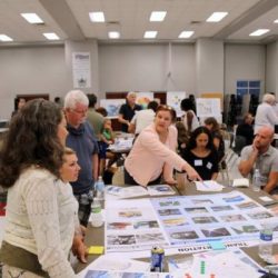
Residents and planners review a map at the LA SAFE Public Open House in Metairie, Louisiana, in October 2017.
By December 2017, OCD and its partners plan to announce the pilot projects derived from LA SAFE in alignment with HUD’s Community Development Block Grant program, making an investment in each of the six target parishes. OCD is currently working with parish leadership, preparing to host another series of community meetings to narrow down what those projects will be. Residents find difficult the task of ranking and prioritizing the wide range of projects and places under consideration. Nevertheless, they continue to show up and even, as Turner did, take on leadership roles as the process reaches its final stages.
“I’m impressed with the level of engagement with the community,” Turner remarked on her experience with Sanders, Hill, Williams, and the rest of the LA SAFE team. “They give a listening ear, which makes us feel like we are a part of the process.” She was drawn to the project because it seems to provide a concrete way to build up the parish, to make a plan to stay. She also wanted to make sure her community and their needs are accurately represented. Still, she reserves judgment on whether the process will pan out as well as administrators hope. “Is there really a chance that we will benefit?” she mused. “I’m at 75 percent about LA SAFE. But I have faith.”
Meanwhile, the fight to protect Louisiana’s disintegrating coastline continues, and time is running short. Flozell Daniels, the president and CEO of Foundation for Louisiana, knows very well how high the stakes are for this project, which promises to deliver not only a solution for our state but a new standard for community-driven adaptation to environmental change. At the community center in Davant this past June, Daniels opened the meeting by providing residents with a sense of the project’s scope. “What we’re doing here tonight,” he explained, “is setting an example for the rest of the country and the world.”
Monica Barra is a cultural anthropologist who writes about environmental change, the politics of racial difference, and their relationship to techno-scientific innovation. She is a research associate with the Water Institute of the Gulf and an instructor in the Environmental Studies program at Tulane University.